This project describes how to estimate cloud base altitude.
Problem statement
Say, you want to launch a rocket to X,000 ft. You look up and see a cloud. How high is it?
Definitions
A few terms to make things easier to explain:
- Cloud – visible mass of liquid droplets suspended in the atmosphere
- Cloud Base Altitude – lowest altitude of the visible portion of the cloud
- AGL – Above Ground Level (as opposed to MSL, Mean Sea Level)
- Dew point – temperature at which the air can no longer “hold” all of the water vapor (so some of vapor must condense into liquid water)
- Relative humidity (%) – amount of moisture in the air compared to what the air can “hold” at that temperature.
How stuff works
First,
- What we know: how to measure temperature and humidity at ground level.
- What we do: we use a sensor to measure temperature and relative humidity.
Second,
- What we know: as the air cools down, sooner or later some of water vapor in the air will condense.
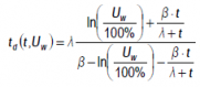
- What we do: from temperature and relative humidity, calculate dew point (see definition above).
Third,
- What we know: with altitude, air cools down at a known rate.
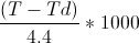
- What we do: we just measured temperature at ground level. Now we calculate at which altitude the temperature will drop to dew point.
What just happened?
We measured local conditions (T°/RH%) and calculated, at which altitude the water in the air will condense into clouds. We calculated Cloud Base Altitude above ground level.
All right, enough boring stuff. Where’s the beef ?