FAA rule 101 governs launch and operation of unmanned free balloons. In a nutshell, balloon is exempt from FAA rules if:
- Payload weight is less than 4 lb
- Rope separates under less than 50 lb of impact force
- Does not create a hazard to people and property
HAB-1 was exempt from FAA regulations. Pretty much I did’t need anyone’s approval nor notify anyone about the launch.
However, for everyone’s safety, I took this project beyond FAA requirements:
- Launch site was chosen away from busy airspace
- Entire balloon flight path lied away from busy airspace
- FAA was notified:
- NOTAM (Notice to Airmen) was filed to make pilots aware of the launch and flight path
- ARTCC (Air Route Traffic Control Center) was notified of the launch and flight path
- Nearest airport tower was notified of the launch and flight path
Choosing launch site
- I went to FlightPlanner web site and printed a map which shows Class B, C, D, E airspace and all special use airspace (marked in circles on the map below)
- I went to WindFinder web site and looked at historical wind patters in my area
- With my breakfast, I looked at flight predictions at CUSF flight predictor
After a few weeks, I came up with three launch sites (marked in asterisks) and desired flight paths (marked in arrows). Final launch location depended on wind pattern on the launch day,

Airspace map for balloon launch
Filing NOTAM with FAA
I think of travel in terms of cities, landmarks, and highways. Pilots and air traffic controllers think in airports and Nav-Aids. Knowing the right language makes working with FAA an easier task.
Before calling FAA, I prepared the following:
- Learned Zulu alphabet
- Found an airport closest to launch site on AirNav
- Calculated distance and bearing from the airport to launch site – in nautical miles and degrees
- Ran a flight predictor on HABHUB and s3research
- Converted launch and landing times to UTC time
It looked like this:
Notice type - HIBAL NOTAM
Launch site - 3 nautical miles east of AQW (Harriman and West Airport)
Direction - east bound reaching flight level 800 (i.e. 80,000 feet)
Launch time - September 20 1500Z (i.e. "Zulu" (UTC) time)
Landing time - September 20 1800Z
Then I called Lockheed-Martin NOTAM Filing Service. It took less than 10 minutes to file it. I looked it up on FAA NOTAM search there it was:
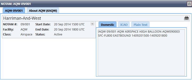
High-Altitude Balloon NOTAM
- AIRSPACE HIGH ALT BALLOON
- AQW090003 = 3 nautical miles from AQW airport at 90° radial (east)
- SFC-FL800 = surface to 80,000 feet
- EASTBOUND = flight path direction
- 1409201500-1409201800 = 9/20/2014 15:00 UTC to 18:00 UTC
Confused? Here’s a better explanation.
Notifying Air Route Traffic Control Center
I called Boston ARTCC and gave them the same information.
Notifying Air Traffic Control Tower
I called Albany ATCT and gave them the same information, and was told to call them one more time, 30 minutes before the launch.